Store, Manage and Share Drone or Cell Photos and Video in the AWS Cloud: Droneware SaaS GeoCMS 90 Day Free Trail

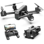
Droneware is a web based discovery tool to store, manage and retrieve photos and video captured from your drone, cell phone or other GPS enabled device. Users can discover their drone data via search, browse, or by location. The Droneware software utilizes drone GPS coordinates at the time the drone’s camera captures data to allow the information to be retrieved and displayed geospatially on a map. Hosted in the Amazon cloud, data is safe, secure, backed up and accessible from anywhere in the world anytime. Droneware is simple and easy to use, providing a valuable tool for commercial utilization or for the hobbyist. Droneware builds a catalog of geospatially tagged data resources that can be used for analytics or just plain fun!
- Manages big data Geotagged data catalogs and allows for metadata search, hierarchical browsing or visual search within a specified map Area of Interest (AOI).
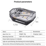
- Capture and manage photos, video, lidar and other data taken from drone platforms. Assigns flight mission name to each set of files uploaded
- Browse photos, videos and other digital data for discovery using a base map (geotagging). Metadata editor allows for metadata enhancement and comments after ingestion
- Droneware uses Amazon AWS cloud services for dissemination of data to anyone in the world 24×7.
- File Format support: JPEG, JPEG 2000, high resolution digital negative formats from Canon, Nikon, and sensors supporting Adobe DNG (TIFF/EP) format, MP4, MOV